Borth-y-Gest: High water is 2 hours and 45 minutes before high water at Liverpool
Abersoch: High water is 3 hours and 15 minutes before high water at Liverpool
Aberdaron: High water is 3 hours before high water at Liverpool
Bardsey Island: High water is 3 hours and 20 minutes before high water at Liverpool
Porth Oer: High water is 2 hours and 30 minutes before high water at Liverpool
Porth Ysgaden: High water is 1 hours and 20 minutes before high water at Holyhead
Porth Dinlaen: High water is 1 hours and 10 minutes before high water at Holyhead
Trefor: High water is 1 hours and 10 minutes before high water at Holyhead
Near Mochras Point: The north north-east going stream begins at 4 hours and 50 minutes after high water at Holyhead. The south south-west going stream begins at 20 minutes after high water at Holyhead. The flow reaches a speed of 1 knots at springs.
Glaslyn Estuary: The east north-east going stream begins at 3 hours and 15 minutes after high water at Liverpool. The west south-west going stream begins at 2 hours and 45 minutes before high water at Liverpool. The flow reaches a speed of 2 knots at springs. Streams are typically much slower.
North side of Tremadoc Bay: Tidal streams along the north side of Tremadoc Bay, especially between Pwllheli and the Glaslyn Estuary, are insignificant.
St. Tudwal's Sound: Inshore of the St. Tudwal Islands: The north north-east going stream begins at 3 hours after high water at Liverpool. The south south-west going stream begins at 3 hours before high water at Liverpool. The flow reaches a speed of 2 knots at springs. The strongest flow is between the islands. A southerly wind will produce rough seas.
Trwyn Cilan: Headland to the east of Hell's Mouth The east going stream begins at 3 hours before high water at Liverpool. The west going stream begins at 3 hours after high water at Liverpool. The flow reaches a speed of 2.5 knots at springs.
Hell's Mouth and SW Lleyn: Tidal streams are generally weak, except at salient points.
Trwyn Talfarach: Headland to the west of Hell's Mouth. The east going stream begins at 3 hours before high water at Liverpool. The west going stream begins at 3 hours after high water at Liverpool. The flow reaches a speed of 2.5 knots at springs.
East entrance to Aberdaron Bay: Between the Gwylan islands and the headland of Ebolion: The east going stream begins at 3 hours before high water at Liverpool. The west going stream begins at 3 hours after high water at Liverpool. The flow reaches a speed of 2.5 knots at springs.
Eddy in Aberdaron Bay: Along the coast to the north of Pen y Cil: An eddy forms here, with the following flows: The north north-east going stream begins at 3 hours before high water at Liverpool. The south south-west going stream begins at 3 hours and 30 minutes after high water at Liverpool.
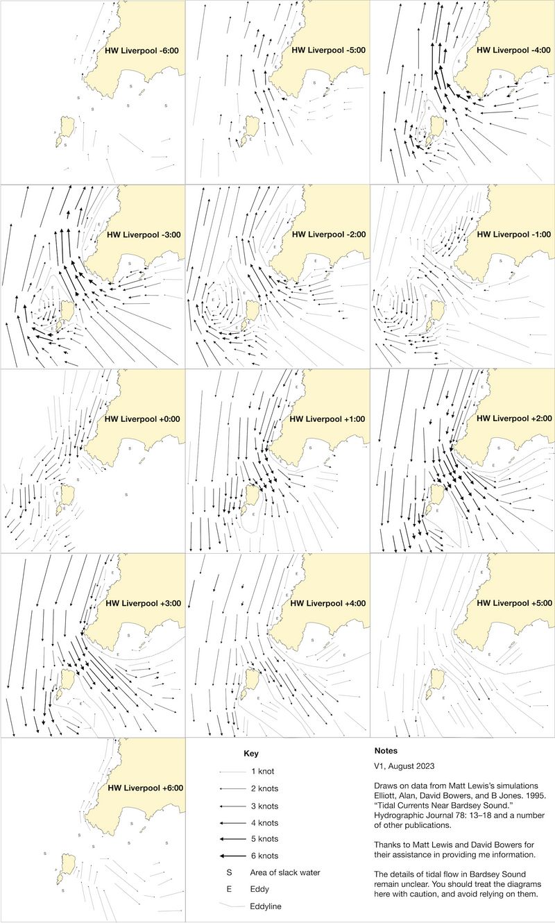
Bardsey Sound: The south-east going stream begins at 45 minutes before high water at Liverpool. The north-west going stream begins at 6 hours and 10 minutes after high water at Liverpool. The south-east going stream reaches a speed of 5 knots at springs. The north-west going stream reaches a speed of 6 knots at springs.. The times of slack water may be around 10 minutes earlier at neaps. Very rough seas can form in wind against tide conditions. The slack water times vary markedly between sources, but having looked closely at all the data available, I think these times are most likely to be correct. There is evidence that the slack water times vary day to day by +/-15 minutes. More information in my flow atlas.
Inshore Bardsey Sound: Eddies cause the tidal streams close inshore east of Braich y Pwll to change differently to those in the main Sound. An eddy forms here, with the following flows: The south-east going stream begins at 3 hours before high water at Liverpool. The north-west going stream begins at 4 hours after high water at Liverpool. The 'young flood' running north-west can be strong. The SE-going inshore flow is likely weaker and may begin later than stated.
West coast of Bardsey Island: The north north-east going stream begins at 5 hours after high water at Liverpool. The south south-west going stream begins at 45 minutes before high water at Liverpool. The flow reaches a speed of 4 knots at springs. During the south-going flow (south-east in Bardsey sound), the flow splits around the island at a location just south of the north-west point of the island. It flows strongly south along the west coast and east along the north coast, although it is reportedly possible to paddles against these streams.
Eddy north-west Bardsey: An eddy flows south-east in the area to the north west of Bardsey during the north-west going flow. This may be especially strong, and cause turbulence, from 5 and half hours before to 2 hours before high water at Liverpool
Eddy east of Bardsey: During the main south-east going flow, an eddy forms to the east of Bardsey, causing a flow north up the coast from Pen Cristin to the north-east point of the island. Flows are less south of Pen Cristin, running gently south towards Maen Du.
Flow around Bardsey on north west stream.: During the north-west going stream, the flow splits around Bardsey Island, flowing north up the coast from Pen Cristin and flowing south towards Maen Du south of the Inlet of Henllwyn. This south-going flow continues flowing south from Maen Du, only turning north to join the flow up the west side of the island some distance south. The stream at Maen Du itself can be very swift and impossible to paddle against. During the North-west going stream, flow is slack on the west coast of Bardsey.
Inshore NW coast of Lleyn Peninsula, near Braich y Pwll: The north north-east going stream begins at 5 hours after high water at Liverpool. The south south-west going stream begins at 3 hours before high water at Liverpool. The flow reaches a speed of 4 knots at springs. Eddy flows make the flows here run differently to those in Bardsey Sound. As a result, the south-going stream at Braich y Pwll can run strongly when Bardsey Sound is slack (around high water Liverpool).
Between Braich y Pwll and Porth Dinllaen: The north-east going stream begins at 5 hours and 50 minutes after high water at Holyhead. The south-west going stream begins at 10 minutes before high water at Holyhead. The flow reaches a speed of 2 knots at springs. There is more flow around salient points, with 3 knots being attained in places. Overfalls form at Penrhyn Mawr.
Carreg Ddu: The east going stream begins at 4 hours after high water at Liverpool. The west going stream begins at 2 hours before high water at Liverpool. The flow reaches a speed of 4 knots at springs. Overfalls form off the point.
Between Porth Dinllaen and Llanddwyn Isalnd: The north-east going stream begins at 5 hours and 50 minutes after high water at Holyhead. The south-west going stream begins at 10 minutes before high water at Holyhead. The flow reaches a speed of 1.5 knots at springs.
Porth Ceiriad: Often surf on the beach.
Hell's Mouth Beach: Is well known for its surf.
Llandanwg: (SH 568 283) g Car park, short carry to the beach
Borth-y-Gest: (SH 565 375) g Large pay and display car park with slipway. Likely not good at low water - usable at least 2 hours either side of local high water.
Criccieth: (SH 505 381) g Parking along the Esplanade and in a large car park behind it. Ramp onto beach.
Abererch: (SH 403 359) g Car park just over the level crossing with height barrier. It may be possible to drop the boats further down the road, close to the holiday park entrance. 150 m from the car park to the beach.
Pwllheli Traeth Glan-y-Don: (SH 384 350) g Large car park by the beach. Height barrier.
Pwllheli Beach: (SH 373 342) g Parking all along the Promenade, a short carry from the beach.
Llanbedrog: (SH 332 314) g National trust pay and display car park near the beach.
Abersoch North: (SH 316 291) g Limited parking on road verge. Carry 150m along a narrow path through the dunes to the beach.
Abersoch Marina: (SH 315 283) g Small parking area, with a short walk to a slipway. Likely better at higher tide levels.
Abersoch Lon Traeth: (SH 317 281) g Small pay car park, closer to the beach than the main pay and display further south.
Abersoch South: (SH 316 277) g Pay and display car park a short distance from a slipway onto the beach. Likely busy on summer weekends.
Machroes: (SH 317 266) g Car park behind sea wall, slipways onto the beach. May be a long walk at low tide.
Porth Neigwl: (SH 282 264) g Small car park. 250m carry to the beach along a sandy path. Be aware that there may be surf on the beach.
Aberdaron: (SH 171 264) g Large car park by the river. Short carry from here onto the beach to launch.
Porth Oer: (SH 166 298) g Road goes down to the beach, but parking is 250 m away at a National Trust car park.
Porth Colmon: (SH 195 342) g Small parking area with slipway onto small beach.
Porth Ysgaden: (SH 220 374) g A track leads to a parking area above the beach, with a track down to the sea.
Porth Dinllaen: (SH 282 408) g The road goes all the way to the beach, and boats could be dropped here. Large National Trust car park up a footpath from here - or drive back to crossroads and turn sharp right.
Trefor: (SH 376 472) g Large beach car park
Aberdesach: (SH 425 515) g Reasonably sized parking area by the beach
Bardsey: Bardsey Island is well worth a visit to explore the ancient remains, visit the one or two wonderfully informal shops and cafes or just sunbathe on the hill watching the tides flow. The tides in Bardsey sound are fast flowing and complex, so getting to Bardsey and back requires careful planning.
Back to index